
Collaborative RAPID Research Project: Study of Soil-Structure Interaction Effects on Behavior and Damage to Structures in Washington D.C. during the August 23, 2011 Virginia Earthquake
Background
The Virginia earthquake of 2011 August 23 occurred as reverse faulting on a northeast-striking plane developed within a previously recognized seismic zone, the “Central Virginia Seismic Zone”. The magnitude of the earthquake was 5.7; the epicenter was located in Louisa County, approximately 89 miles southwest of Washington D.C. The Central Virginia Seismic Zone has produced small and moderate earthquakes since at least the 18th century. The previous largest historical shock from the Central Virginia Seismic Zone occurred in 1875. Following the recent earthquake, the PI and co-PIs participated in reconnaissance efforts on behalf of EERI and GEER to survey and document structural damage and conduct geotechnical surveys in Louisa County and in the Washington D.C. area. In Washington D.C., damage occurred to a number of structures, including the Smithsonian Institute Museum Support Center (MSC) and the Washington National Monument. The performance of both of these structures is of importance, for the construction of the MSC represents typical warehouse buildings in the eastern U.S. The Washington Monument is the world’s tallest stone structure and the world’s tallest obelisk, while also being of national historical significance.
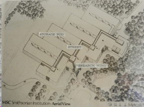
Figure 1. Aerial View of Smithsonian Institute Museum Support Center
An aerial view of the MSC is shown below in Figure 1. The MSC is a warehouse complex that was built in the early 1980s and dedicated in 1983. The structural concept for MSC consists of concrete framed construction with in-filled masonry wall and concrete double T beam roofs. The interior storage locations of artifacts, referred to as storage pods, consists of three floors of steel construction with standard type mezzanine floors consisting of concrete cast on top of metal decking. The storage pods were constructed as part of a renovation in 2010. The lateral force resisting system (LFRS) for the storage pods consist of x-bracing. The steel storage pods area construction is independent of the warehouses, except they share the same foundation. The earthquake damage to the MSC consists of cracking and spalling at various locations of the in-fill masonry walls, stairwell failure in reinforced concrete columns, sliding of the T beams on their supports. In addition, the LFRS of the storage pods sustained brace buckling, brace fracture, weld failure, and foundation bolt shear failure and pullout in several braced bays (see Figure 2).

Figure 2. Damage to Smithsonian Institute Museum Support Center: (a) stairwell concrete column failure at first mezzanine floor level; (b) diagonal brace buckling, tension yielding, and (c) anchor bolt failure of storage pod steel frame lateral load resisting system.
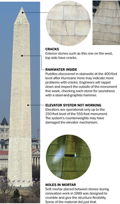
Figure 3. Earthquake Damage to Washington Monument (from http://www.washingtonpost.com/rw/2010-2019/WashingtonPost/2011/09/26/Local/Graphics/w-monument.jpg)
The Washington Monument is made of marble, granite, and bluestone gneiss and stands 555 feet 5 1⁄8 inches (169.294 m). It has a pyramidal point case from aluminum. Construction of the structure was completed in 1888. The damage to the Monument sustained from the earthquake included cracks, surface spalls, and dislodging of stone blocks in the pyramidal, crumbled mortar, as well as damage to the elevator (see Figure 3).
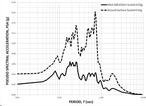
Figure 4. Preliminary MSC site response
The damage that was observed in these two structures is related to the geotechnical features of the soil in the Washington D.C. area. The soil in the area consists of coastal plain deposits located on shallow bedrock. The ground motions from eastern U.S. earthquakes are therefore more widely felt. Shown in Figure 4 are the results of a preliminary MSC site response analysis performed by the PIs. There is considerable amplification of the spectral accelerations in the 0.2 to 1.0 second range, representing the range of periods that the MSC and Washington Monuments fundamental periods of vibration likely fall. It is apparent that the local soil conditions are an important element that led to the cause of damage, and that the damage is related to the effects of soil-structure interaction.
Source and Path Propagation Effects; Realistic Simulation of Ground Motion in the DC Area
The earthquake was an unusually shallow reverse faulting event that ruptured to near the ground surface. The fault plane is well defined by both moment tensor inversion and the highly accurate hypocenter locations of several dozen aftershocks. The fault plane strikes N29E and dips 51 degrees to the southeast. The focal depth of major moment release was approximately 6 km. That is less than the mean depth of 8 km for previous earthquakes instrumentally located in the central Virginia seismic zone (Chapman 2011b). Preliminary results of a study underway by Chapman, a PI on the Virginia Tech proposal, indicate that the mainshock was not a simple rupture but instead was a complex event comprised of a small rupture initiation pulse followed within 2 seconds by two major subevents responsible for most of the moment release (Chapman, 2011a, 2011b). The rupture initiated at a depth of approximately 7 km at the extreme southwestern corner of what would eventually become the aftershock zone. The rupture front propagated unilaterally up-dip and along strike to the northeast, slightly slower than the S-wave velocity. This highly irregular, unit-directional rupture is likely responsible for the strong asymmetry of the USGS isoseismal maps produced from public reports which show pronounced amplification of the ground motion to the north and northeast of the epicenter in the direction of forward directivity, affecting the northern Virginia and Washington DC areas. Furthermore, the shallow focal depth of the source contributed substantially to the amplitude of longer period (e.g., greater than 1 second) surface wave amplitudes. In addition to this, two stations in Virginia, at Corbin (ANSS station CBN near Fredericksburg) and at Richmond (Virginia Tech broadband station URVA), show large displacements due to Raleigh wave-like motion (1.25 second period) between the P and S wave arrivals. This P-coupled surface wave is rarely observed and is not well understood. Shallow focal depth and special velocity structure of the upper crust is required for its generation and propagation with large amplitude. It is possible that this phase propagated beyond Fredericksburg, VA into the DC area. If so, it would have contributed to damage to longer period structures, such as the Washington National Monument. The observation of unusual intermediate and long-period motion at CBN and URVA cannot be corroborated for DC because no ground motion data were recorded in that area. This is unfortunate and indicates the need to locate stations in the DC area to record future earthquakes, given the seismic hazard of the nation’s capital and it is symptomatic of the completely inadequate state of the earthquake monitoring infrastructure in the entire eastern United States. However, because of the data set collected from the aftershocks, by Virginia Tech, other universities, IRIS and the USGS, and the fact that the mainshock and some of the larger aftershocks were co-recorded by three ANSS and three Virginia Tech seismic network stations within several tens of kilometers of the epicenter, it is possible to invert for a rupture model. Given that, we can in-turn model the mainshock wavefield in the DC area with some confidence. Such has already been done for the North Anna power plant site, and the synthetic strong motions are in good agreement with the strong motion data recorded at that site (Chapman, 2011a). A finite fault simulation of the mainshock rupture process combined with full wavefield Green’s functions will be used to compute ground motions in the DC area. This should provide constraint on the ground motion experienced in the vicinity of the structures that suffered extensive damage. In fact, if good geotechnical site characterization is possible, in terms of site-specific shallow velocity structure, three-component full wavefield synthetics for the sites of interest can be computed. This will be much more realistic and meaningful than the 1-D vertical incidence site response analyses commonly produced for engineering purposes.
Research Program Plan and Expected Outcomes
The project consists of a more detailed in-depth study of the MSC and Washington Monuments to assess the roles that the structural system and geotechnical features played in their performance during the 2011 Virginia earthquake. The primary research tasks are summarized:
- Gather perishable data from the MSC and Washington Monument sites; completing field observations to thoroughly document structural damage and obtain necessary dimensions for structural modeling purposes.
- Perform field vibration tests and modal identification analysis to establish the dynamic characteristics of MSC and Washington Monument structures (periods of vibration, natural damping properties and mode shapes).
- Develop 3-D finite element models of these structures, using the data from (2) as a means of calibrating the models.
- Working with USGS researchers, perform field measurements and Spectral Analysis of Surface Waves (SASW) at the two study sites to characterize dynamic parameters, including shear wave (Vs) and compressive wave (Vp) velocities of soils.
- Using recorded M5.7 motions from North Anna Power Plant, Reston, Fredricksburg, along with aftershock recordings from the source region for calibration, develop an advanced finite-fault model of the M5.7 mainshock rupture. This will build on the modeling being done currently by Dr. Chapman at Virginia Tech. The calibrated finite fault model will be used to generate simulated M5.7 ground motions accounting for specific geological and geotechnical conditions at each site.
- Using the structural models, dynamic site parameters, and advanced ground motion models, perform dynamic soil-structure interaction analyses of both facilities to explain the observed response during the M5.7 earthquake.
- Modify the input ground motions to simulate different earthquake scenarios to better understand and communicate the potential implications of the M5.7 or larger-magnitude event occurring closer to Washington, DC or other populated areas in the region
- Disseminate the findings, develop larger Central and Eastern North America CENA study.
The PIs from Lehigh and Virginia Tech are working collaboratively with each other and with USGS as noted above. Lehigh researchers are focusing on structural performance, identification, and modeling (Tasks 1, 2, 3). Virginia Tech researchers are performing site characterization tasks and developing finite element models of the geotechnical features of the sites and generation of simulated ground motions to be used for the soil-structure interaction analysis (Tasks 4 and 5). The structural identification and site characterization tests are being conducted with USGS (Dr. Rob Kayen). The Lehigh and Virginia Tech research teams are collaboratively performing 3-D time history analysis with soil-structure interaction effects, evaluating the effects of local site conditions and construction on structural response, and disseminating findings (Tasks 6, 7, and 8). The owners/managers of the two structures have agreed to cooperate with the research team, providing access to the structures to conduct the research.
In terms of intellectual merit, the two structures represent a unique opportunity to study the behavior of east-cost structures not designed to resist earthquakes and the effects of soil-structure interaction that led to damage. A more in-depth study of the response of these two structures is important to more thoroughly assess the role that the geotechnical features at the sites and the non-seismic construction played in the observed structural performance and damage. From this study additional lessons can be learned about the significance of these two aspects. In terms of broader impact, the results from this study will be of value to the profession in establishing the vulnerability of eastern U.S. structures and needs for renovation to ensure their resiliency.
The results of the study are to be disseminated via presentations at technical conferences and publications in refereed journals.
Project Team
|
Team Member |
Relevant Expertise |
Role in Project |
| James Ricles, Ph.D.,P.E. Professor Lehigh University, PI |
Nonlinear finite element modeling, seismic structural analysis, EQ reconnaissance | Data collection and analysis; Damage assessment; Structural modeling and analysis; SSI analysis; Dissemination of findings; Outreach. |
| Shamim Pakzad, Ph.D. Assistant Professor Lehigh University, Co-PI |
Structural health monitoring, Wireless sensor networks, Damage detection, Signal processing | Data collection and analysis; Field vibration tests and modal identification; Structural modeling and analysis; SSI analysis; Dissemination of finding;Outreach. |
| James Martin, Ph.D. Professor Virginia Tech, PI |
Geotechnical earthquake and foundation engineering, site response, numerical modeling | Data collection and analysis; Field measurements and SASW; Site characterization; Soil modeling and analysis; SSI analysis; Dissemination of findings; Outreach. |
| Martin Chapman, Ph.D. Director VTSOVirginia Tech, Co-PI |
Geophysics; Seismicity and tectonics of interior plates; Strong-motion seismology | Data collection and analysis; Field measurements; Site characterization; Finite-fault modeling and generation of simulated ground motions; Dissemination of findings; Outreach. |
| Xin Chu Graduate Research Assist Lehigh University |
Steel braced frame analysis, nonlinear dynamic analysis, modal testing | Conduct field observations and modal testing; develop and perform finite element time history analysis of MSC. |
| Golnaz Shahidi, MSc. Graduate Research Assist Lehigh University |
System identification, modal testing, nonlinear dynamic analysis | Conduct field observations and modal testing; develop and perform finite element time history analysis of the Washington Monument |
| Hillary Brooker Undergraduate Res Assist Lehigh University |
Finite element analysis, Field reconnaissance | Conduct field observations; assist in developing finite element model of the Washington Monument. |
| Guney C. Olgun, Ph.D. ProfessorVirginia Tech |
Geotechnical Earthquake Engineering, numerical analysis, sites response | Dynamic soil-structure interaction analysis, site response analyses, development of regional site-specific amplification factors. |
| Morgan Eddy, MSc. PhD Candidate Virginia Tech |
Geotechnical Earthquake Engineering; site response, field reconnaissance | Site response analyses, development of regional site-specific amplification factors for building codes. |
| Betsey Godfrey Undergraduate Res Assist Virginia Tech |
Geotechnical Earthquake Engineering; site response, field reconnaissance | Site response analyses, development of regional site-specific amplification factors for building codes. |
| Jingjie Chen Undergraduate Res Assist Virginia Tech |
Geotechnical Earthquake Engineering | Development of GIS geotechnical data base and correlation of intensity data, building damage, and geotechnical conditions. |
